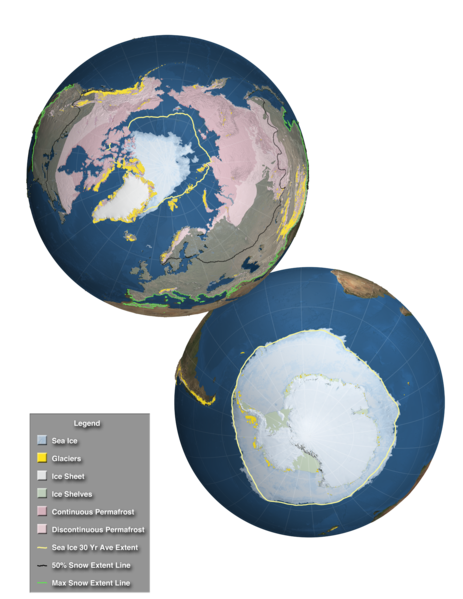
Fájl:Components of the Cryosphere.tif
Megjelenés

Ennek a(z) TIF fájlnak ezen PNG formátumú előnézete: 463 × 599 képpont. További felbontások: 185 × 240 képpont | 371 × 480 képpont | 593 × 768 képpont | 791 × 1 024 képpont | 2 048 × 2 650 képpont.
Eredeti fájl (2 048 × 2 650 képpont, fájlméret: 20,91 MB, MIME-típus: image/tiff)
Fájltörténet
Kattints egy időpontra, hogy a fájl akkori állapotát láthasd.
| Dátum/idő | Bélyegkép | Felbontás | Feltöltő | Megjegyzés | |
|---|---|---|---|---|---|
| aktuális | 2013. december 3., 15:22 |  | 2 048 × 2 650 (20,91 MB) | Originalwana | {{Information |Description ={{en|1=This high resolution image, designed for the Fifth Assessment Report of the Intergovernmental Panel on Climate Change, shows the extent of the regions affected by components of the cryosphere around the world. Over... |
Fájlhasználat
Az alábbi lap használja ezt a fájlt:
Globális fájlhasználat
A következő wikik használják ezt a fájlt:
- Használata itt: azb.wikipedia.org
- Használata itt: de.wikipedia.org
- Használata itt: es.wikipedia.org
- Használata itt: eu.wikipedia.org
- Használata itt: fr.wiktionary.org
- Használata itt: he.wikipedia.org
- Használata itt: hi.wikipedia.org
- Használata itt: ja.wikipedia.org
- Használata itt: ky.wikipedia.org
- Használata itt: la.wikipedia.org
- Használata itt: sr.wikipedia.org
- Használata itt: sv.wikipedia.org
- Használata itt: th.wikipedia.org
- Használata itt: vi.wikipedia.org
- Használata itt: www.wikidata.org
- Használata itt: zh-yue.wikipedia.org


