
Fájl:Spanish Empire Anachronous en.svg

Ennek a(z) SVG fájlnak ezen PNG formátumú előnézete: 800 × 407 képpont. További felbontások: 320 × 163 képpont | 640 × 325 képpont | 1 024 × 520 képpont | 1 280 × 650 képpont | 2 560 × 1 301 képpont | 2 753 × 1 399 képpont.
Eredeti fájl (SVG fájl, névlegesen 2 753 × 1 399 képpont, fájlméret: 1,12 MB)
|
Ez a fájl a Wikimedia Commonsból származik. Az alább látható leírás az ottani dokumentációjának másolata. A Commons projekt szabad licencű kép- és multimédiatár. Segíts te is az építésében! |
Összefoglaló
| Leírás |
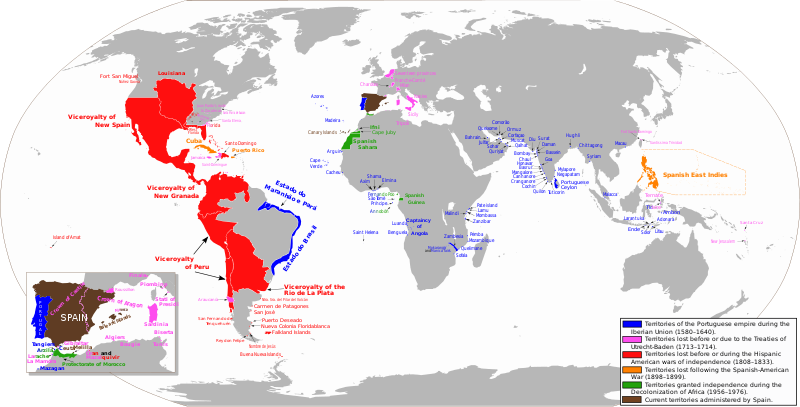
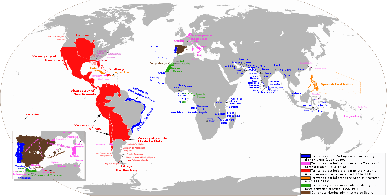
Español: Mapa diacrónico de los territorios del Imperio Español
Territorios del imperio portugués durante la Unión Ibérica (1580-1640)
Territorios hasta los Tratados de Utrecht-Baden (1713–1714)
Territorios hasta las Guerras de independencia hispanoamericana (1808–1833)
Territorios hasta la Guerra Hispano-Estadounidense (1898-1899)
Territorios hasta la Descolonización de África (1956-1976)
Territorios actualmente administrados por España English: Anachronous map of the Spanish Empire
Territories of the Portuguese empire during the Iberian Union (1580-1640)
Territories until the Treaties of Utrecht-Baden (1713–1714)
Territories until the Spanish American wars of independence (1808–1833)
Territories until the Spanish-American War (1898-1899)
Territories granted independence during the Decolonization of Africa (1956-1976)
Current territories administered by Spain |
| Dátum | |
| Forrás | A feltöltő saját munkája. View sources in talk page |
| Szerző | Trasamundo |
| Engedély (Fájl újrafelhasználása) |
trabajo propio (own work) |
| Más változatok |
 |
Licenc
Én, e mű szerzője a művemet az alábbi licencek alatt teszem közzé:

|
Ez a fájl szabadon másolható, terjeszthető és/vagy módosítható a GNU Szabad Dokumentációs Licenc feltételei alapján, az 1.2 vagy későbbi, a Free Software Foundation által publikált Nem Változtatható szakaszok, Címlapszövegek és Hátlapszövegek nélküli változat szerint. E licenc egy példánya a GNU Szabad Dokumentációs Licenc című fejezetben olvasható. |
Ez a fájl a Creative Commons Nevezd meg! – Így add tovább! 3.0 Unported, 2.5 Általános, 2.0 Általános és 1.0 Általános licencek alapján használható fel.
- A következőket teheted a művel:
- megoszthatod – szabadon másolhatod, terjesztheted, bemutathatod és előadhatod a művet
- feldolgozhatod – származékos műveket hozhatsz létre
- Az alábbi feltételekkel:
- Nevezd meg! – A szerzőt megfelelően fel kell tüntetned, hivatkozást kell létrehoznod a licencre és jelezned kell, ha a művön változtatást hajtottál végre. Ezt bármilyen észszerű módon megteheted, kivéve oly módon, ami azt sugallná hogy a jogosult támogat téged vagy a felhasználásod körülményeit.
- Így add tovább! – Ha megváltoztatod, átalakítod, feldolgozod ezt a művet, a közreműködésedet csak az eredetivel megegyező vagy hasonló licenc alatt terjesztheted.
A mű a fenti licencek bármelyike szerint felhasználható.
Fájltörténet
Kattints egy időpontra, hogy a fájl akkori állapotát láthasd.
| Dátum/idő | Bélyegkép | Felbontás | Feltöltő | Megjegyzés | |
|---|---|---|---|---|---|
| aktuális | 2023. május 1., 03:15 | | 2 753 × 1 399 (1,12 MB) | Janitoalevic | Fixed borders and added Araucanía |
| 2023. április 24., 09:57 |  | 2 753 × 1 399 (1,01 MB) | Durero | Araucanía lost after mapuche rebelions. Restored previous version beacuse of borders | |
| 2023. február 13., 17:05 |  | 2 753 × 1 399 (1,12 MB) | Janitoalevic | Added border between Chile and Perú, full Esequibo territory, Buena Nueva Islands and San Fernando de Tenquehuén. | |
| 2019. november 27., 20:25 |  | 2 753 × 1 399 (1,01 MB) | FDRMRZUSA | Corrected error (Siena) for "great" map too. In previous update the correction was restricted to the "little" map (box) on the lower left. No other changes. | |
| 2019. november 27., 20:00 |  | 2 753 × 1 399 (1,01 MB) | FDRMRZUSA | Restored version of 9 June 2013 (latest updated version) but with corrected mistake: Siena was part of the Granduchy of Tuscany. No other changes. | |
| 2019. november 15., 19:31 |  | 2 753 × 1 400 (1,37 MB) | Barjimoa | Reverted to version as of 18:53, 29 March 2009 (UTC) Correcting mistake: Siena was part of the Granduchy of Tuscany. | |
| 2013. június 9., 22:21 |  | 2 753 × 1 399 (1,33 MB) | Trasamundo | Oceanía | |
| 2013. január 28., 20:27 |  | 2 753 × 1 400 (1,53 MB) | Trasamundo | dates | |
| 2012. szeptember 6., 20:51 |  | 2 753 × 1 400 (1,49 MB) | Trasamundo | Iberian Peninsula | |
| 2011. március 29., 22:27 |  | 2 753 × 1 400 (1,52 MB) | Trasamundo | North Amarica: fixing the geographical accuracy, missions, forts |
Fájlhasználat
Az alábbi lap használja ezt a fájlt:
Globális fájlhasználat
A következő wikik használják ezt a fájlt:
- Használata itt: af.wikipedia.org
- Használata itt: azb.wikipedia.org
- Használata itt: be.wikipedia.org
- Használata itt: bn.wikibooks.org
- Használata itt: da.wikipedia.org
- Használata itt: de.wikipedia.org
- Használata itt: el.wikipedia.org
- Használata itt: en.wikipedia.org
- Használata itt: en.wikibooks.org
- Használata itt: es.wikipedia.org
- Használata itt: et.wikipedia.org
- Használata itt: fi.wikipedia.org
- Használata itt: fr.wikipedia.org
- Használata itt: gl.wikipedia.org
- Használata itt: gn.wikipedia.org
- Használata itt: he.wikipedia.org
- Használata itt: hy.wikipedia.org
- Használata itt: id.wikipedia.org
- Használata itt: ko.wikipedia.org
- Használata itt: lt.wikipedia.org
A fájl globális használatának megtekintése