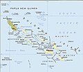
Fájl:Political map of the Solomon Islands archipelago in 1989.jpg
Megjelenés

Az előnézet mérete: 690 × 600 képpont További felbontások: 276 × 240 képpont | 552 × 480 képpont | 748 × 650 képpont.
Eredeti fájl (748 × 650 képpont, fájlméret: 72 KB, MIME-típus: image/jpeg)
Fájltörténet
Kattints egy időpontra, hogy a fájl akkori állapotát láthasd.
| Dátum/idő | Bélyegkép | Felbontás | Feltöltő | Megjegyzés | |
|---|---|---|---|---|---|
| aktuális | 2016. április 12., 03:06 |  | 748 × 650 (72 KB) | Nimbosa | Reverted to version as of 02:02, 12 April 2016 (UTC) |
| 2016. április 12., 03:05 |  | 748 × 650 (72 KB) | Nimbosa | restored to original color as on print, corrected color map | |
| 2016. április 12., 03:02 |  | 748 × 650 (72 KB) | Nimbosa | restored to original color as on print, corrected color map | |
| 2007. március 1., 22:09 |  | 748 × 650 (72 KB) | Pibwl |
Fájlhasználat
Az alábbi lap használja ezt a fájlt:
Globális fájlhasználat
A következő wikik használják ezt a fájlt:
- Használata itt: als.wikipedia.org
- Használata itt: ami.wikipedia.org
- Használata itt: ast.wikipedia.org
- Használata itt: bg.wikipedia.org
- Használata itt: bn.wikipedia.org
- Használata itt: ca.wikipedia.org
- Használata itt: ceb.wikipedia.org
- Használata itt: cs.wikipedia.org
- Használata itt: da.wikipedia.org
- Használata itt: el.wikipedia.org
- Használata itt: en.wikipedia.org
- Használata itt: en.wiktionary.org
- Használata itt: es.wikipedia.org
- Használata itt: fa.wikipedia.org
- Használata itt: fi.wikipedia.org
- Használata itt: fr.wikipedia.org
- Használata itt: gl.wikipedia.org
- Használata itt: hy.wikipedia.org
- Használata itt: hyw.wikipedia.org
- Használata itt: id.wikipedia.org
- Használata itt: it.wikipedia.org
- Használata itt: ja.wikipedia.org
- Használata itt: ja.wiktionary.org
- Használata itt: ka.wikipedia.org
- Használata itt: kk.wikipedia.org
A fájl globális használatának megtekintése


