Ugrás a tartalomhoz

Fájl:Map of route of Lancaster's chevauchée of 1346.svg

Az oldal más nyelven nem érhető el.
A Wikipédiából, a szabad enciklopédiából

Eredeti fájl (SVG fájl, névlegesen 698 × 1 064 képpont, fájlméret: 303 KB)

Összefoglaló

Leírás
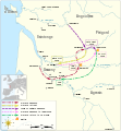
English: Map of the route of Lancaster's chevauchée of 1346, part of the Hundred Years' War. This map shows the Lancaster's movements during the campaign and the most important sieges and sackings of towns.
institution QS:P195,Q12551
institution QS:P195,Q60791481
Dátum
Forrás

A feltöltő saját munkája
Ez a fájl ebből származik:

Derived from;

Information from:

Szerző Goran_tek-en
Engedély
(Fájl újrafelhasználása)
w:hu:Creative Commons
Nevezd meg! Így add tovább!
Ez a fájl a Creative Commons Nevezd meg! – Így add tovább! 4.0 Nemzetközi licenc alapján használható fel.
Így nevezd meg: Goran tek-en
A következőket teheted a művel:
  • megoszthatod – szabadon másolhatod, terjesztheted, bemutathatod és előadhatod a művet
  • feldolgozhatod – származékos műveket hozhatsz létre
Az alábbi feltételekkel:
  • Nevezd meg! – A szerzőt megfelelően fel kell tüntetned, hivatkozást kell létrehoznod a licencre és jelezned kell, ha a művön változtatást hajtottál végre. Ezt bármilyen észszerű módon megteheted, kivéve oly módon, ami azt sugallná hogy a jogosult támogat téged vagy a felhasználásod körülményeit.
  • Így add tovább! – Ha megváltoztatod, átalakítod, feldolgozod ezt a művet, a közreműködésedet csak az eredetivel megegyező vagy hasonló licenc alatt terjesztheted.
This work contains information from OpenStreetMap, which is made available under the Open Database License (ODbL).

The ODbL does not require any particular license for maps produced from ODbL data. Prior to 1 August 2020, map tiles produced by the OpenStreetMap Foundation were licensed under the CC-BY-SA-2.0 license. Maps produced by other people may be subject to other licences.

Más változatok
SVG kód
InfoField
 
Ezen SVG kép forráskódja érvényes.
 
Ez vektorgrafikus kép Inkscape segítségével készült.
Objektum elhelyezkedése45° 19′ 40,8″ É, 0° 22′ 12,72″ Ny Kartographer map based on OpenStreetMap.További képek erről a helyről: OpenStreetMapinfo

Képaláírások

Adj meg egy egysoros magyarázatot arról, hogy mit mutat be ez a fájl
Map of the route of Lancaster's chevauchée of 1346, part of the Hundred Years' War.

22. november 2018

45°19'41"N, 0°22'12"W

Fájltörténet

Kattints egy időpontra, hogy a fájl akkori állapotát láthasd.

Dátum/időBélyegképFelbontásFeltöltőMegjegyzés
aktuális2021. november 9., 19:41Bélyegkép a 2021. november 9., 19:41-kori változatról698 × 1 064 (303 KB)Goran tek-enChanged color to work better for people with color deficiency
2021. november 9., 19:30Bélyegkép a 2021. november 9., 19:30-kori változatról698 × 1 064 (303 KB)Goran tek-enChanged view box, font size and some more
2018. november 22., 16:59Bélyegkép a 2018. november 22., 16:59-kori változatról698 × 1 064 (205 KB)Goran tek-en{{Information |description ={{en|1=Map of the route of Lancaster's chevauchée of 1346, part of the Hundred Years' War. This map shows the Lancaster's movements during the campaign and the most important sieges and sackings of towns.}} |date =20181122 |source ={{Own}}<br> Derived from; * [https://www.openstreetmap.org/#map=8/45.141/0.549 OSM] Information from: * [https://web.archive.org/web/20170425121316/https://erenow.com/postclassical/trialbybattle/16.html Web archiv...

Az alábbi lap használja ezt a fájlt:

Globális fájlhasználat

A következő wikik használják ezt a fájlt:

Metaadatok