
Fájl:HMS Queen Elizabeth alongside HMS Illustrious.jpg
Nem érhető el nagyobb felbontású változat.
HMS_Queen_Elizabeth_alongside_HMS_Illustrious.jpg (752 × 423 képpont, fájlméret: 78 KB, MIME-típus: image/jpeg)
|
Ez a fájl a Wikimedia Commonsból származik. Az alább látható leírás az ottani dokumentációjának másolata. A Commons projekt szabad licencű kép- és multimédiatár. Segíts te is az építésében! |
Összefoglaló
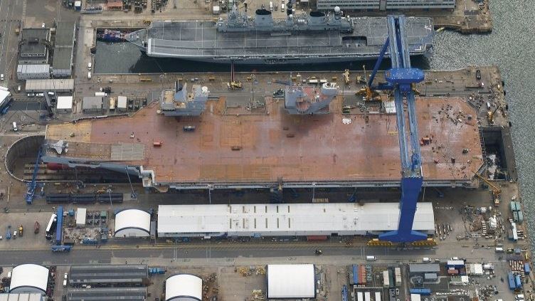
| Leírás |
English: HMS Queen Elizabeth alongside HMS Illustrious |
| Dátum | |
| Forrás | http://www.aircraftcarrieralliance.co.uk/~/media/Images/A/Aircraft-Carrier-Alliance-V2/content-images/Image%20Library/collection/hms-illustrious-at-rosyth_preview.jpg?h=355&la=en&w=500 |
| Szerző | Aircraft Carrier Alliance |
| Engedély (Fájl újrafelhasználása) |
OGL (Open Government Licence) |
| Fényképező elhelyezkedése | | További képek erről a helyről: OpenStreetMap |
|---|
Licenc
_(St_Edwards_Crown).svg)
|
This file is licensed under the Open Government Licence version 1.0 (OGL v1.0).
|
|---|---|
| Így nevezd meg:Photo: HMS Queen Elizabeth/MOD | |
|
You are free to:
See the Open Government Licence page on Meta-Wiki for more information.
|
Fájltörténet
Kattints egy időpontra, hogy a fájl akkori állapotát láthasd.
| Dátum/idő | Bélyegkép | Felbontás | Feltöltő | Megjegyzés | |
|---|---|---|---|---|---|
| aktuális | 2014. július 4., 23:23 | | 752 × 423 (78 KB) | Twobells | User created page with UploadWizard |
Fájlhasználat
Az alábbi lap használja ezt a fájlt:
Globális fájlhasználat
A következő wikik használják ezt a fájlt:
- Használata itt: bn.wikipedia.org
- Használata itt: cs.wikipedia.org
- Használata itt: en.wikipedia.org
- Használata itt: ja.wikipedia.org
- Használata itt: ko.wikipedia.org
- Használata itt: ms.wikipedia.org
- Használata itt: nl.wikipedia.org
- Használata itt: pl.wikipedia.org
- Használata itt: pt.wikipedia.org