
Fájl:HMSO Graf Spee map of River Plate.jpg
HMSO_Graf_Spee_map_of_River_Plate.jpg (751 × 517 képpont, fájlméret: 57 KB, MIME-típus: image/jpeg)
|
Ez a fájl a Wikimedia Commonsból származik. Az alább látható leírás az ottani dokumentációjának másolata. A Commons projekt szabad licencű kép- és multimédiatár. Segíts te is az építésében! |
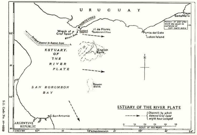
| Leírás | Map of the estuary of the River Plate showing possible exit channels available to the German heavy cruiser Admiral Graf Spee after the Battle of the River Plate in December 1939. | |||
| Dátum | ||||
| Forrás |
From official British report into the cruise of the Graf Spee and Battle of the River Plate. Published by HMSO (His Majesty's Stationery Office). Originally uploaded to EN Wikipedia as en:File:HMSO Graf Spee map of River Plate.jpg by en:User:Duncharris 26 December 2004; modified by en:User:Lhgodoy 22 March 2006. |
|||
| Szerző | British Government | |||
| Engedély (Fájl újrafelhasználása) |
Crown Copyright expired (50 years)
|
|||
| Más változatok | en:File:HMSO Graf Spee map of River Plate.jpg |

Fájltörténet
Kattints egy időpontra, hogy a fájl akkori állapotát láthasd.
| Dátum/idő | Bélyegkép | Felbontás | Feltöltő | Megjegyzés | |
|---|---|---|---|---|---|
| aktuális | 2009. december 20., 18:05 | | 751 × 517 (57 KB) | Rcbutcher | {{Information |Description=Map of the estuary of the River Plate showing possible exit channels available to the German heavy cruiser Admiral Graf Spee after the Battle of the River Plate in December 1939. |Source=From official British report into the cru |
Fájlhasználat
Az alábbi lap használja ezt a fájlt:
Globális fájlhasználat
A következő wikik használják ezt a fájlt:
- Használata itt: azb.wikipedia.org
- Használata itt: ca.wikipedia.org
- Használata itt: de.wikipedia.org
- Használata itt: en.wikipedia.org
- Használata itt: es.wikipedia.org
- Használata itt: it.wikipedia.org
- Használata itt: nl.wikipedia.org