Ugrás a tartalomhoz

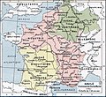
Fájl:Francia at the death of Pepin of Heristal, 714.jpg

Az oldal más nyelven nem érhető el.
A Wikipédiából, a szabad enciklopédiából

Eredeti fájl (1 254 × 1 149 képpont, fájlméret: 1 MB, MIME-típus: image/jpeg)

Összefoglaló

Leírás
English: Francia at the death of Pepin of Heristal, 714
Français : Gaule à l'avènement de Charles Martel (714).
Dátum
Forrás Paul Vidal de la Blache's Atlas général d'histoire et de géographie (1912). The original scanned image can be found at http://www.hipkiss.org/data/maps/vidal-lablache_atlas-general-histoire-et-geographie_1912_ancient-gaul-merovian-merovingienne_2953_4252_600.jpg. Information on the original scan can be found at http://www.hipkiss.org/cgi-bin/maps.pl?book=Vidal%20Lablache%20-%20Atlas%20General%20Histoire%20Et%20Geographie.
Szerző
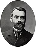
Paul Vidal de La Blache  (1845–1918)  wikidata:Q311865 s:fr:Auteur:Paul Vidal de La Blache q:fr:Paul Vidal de La Blache
 
Paul Vidal de La Blache
További nevei
Paul Vidal de la Blanche
Leírás francia geográfus és térképész
Születési és halálozási dátum 1845. január 22. Szerkesztés a Wikidatán 1918. április 5. Szerkesztés a Wikidatán
Születés és halálozás helye Pézenas Szerkesztés a Wikidatán La Seyne-sur-Mer Szerkesztés a Wikidatán
Nemzetközi katalógus
creator QS:P170,Q311865
Más változatok
Ez a kép elérhető vektorgrafikus (SVG) változatban is. Ha jobb minőségű, azt használd e helyett a raszterkép helyett.

File:Francia at the death of Pepin of Heristal, 714.jpg → File:Francia at the death of Pepin of Heristal 714-es.svg

A vektorgrafikáról a Help:SVG oldalon találsz információkat.

Más nyelveken
Alemannisch  العربية  беларуская (тарашкевіца)  български  বাংলা  català  нохчийн  čeština  dansk  Deutsch  Ελληνικά  English  British English  Esperanto  español  eesti  euskara  فارسی  suomi  français  Frysk  galego  Alemannisch  עברית  hrvatski  magyar  հայերեն  Bahasa Indonesia  Ido  italiano  日本語  ქართული  한국어  lietuvių  македонски  മലയാളം  Bahasa Melayu  norsk bokmål  Plattdüütsch  Nederlands  norsk nynorsk  norsk  occitan  polski  prūsiskan  português  português do Brasil  română  русский  sicilianu  Scots  slovenčina  slovenščina  српски / srpski  svenska  தமிழ்  ไทย  Türkçe  татарча / tatarça  українська  vèneto  Tiếng Việt  中文  中文(中国大陆)  中文(简体)  中文(繁體)  中文(马来西亚)  中文(新加坡)  中文(臺灣)  中文(臺灣)  +/−
Az új SVG kép

Licenc

This image is in the public domain because it is a mere mechanical scan or photocopy of a public domain original, or – from the available evidence – is so similar to such a scan or photocopy that no copyright protection can be expected to arise. The original itself is in the public domain for the following reason:
Public domain

A szerző halálozási ideje 1918, ezért ez a mű közkincs abban az országban, ahol elkészítették, és minden olyan további államban, ahol a szerzői jogi védelmi idő a szerző élete plusz 100 év vagy kevesebb.


Ez az alkotás az Amerikai Egyesült Államokban közkincsnek számít, mivel 1929. január 1. előtt publikálták.

Megállapították, hogy ez a fájl mentes mindenféle szerzői jogi korlátozástól, beleértve az összes kapcsolódó és hozzátartozó jogot.

This tag is designed for use where there may be a need to assert that any enhancements (eg brightness, contrast, colour-matching, sharpening) are in themselves insufficiently creative to generate a new copyright. It can be used where it is unknown whether any enhancements have been made, as well as when the enhancements are clear but insufficient. For known raw unenhanced scans you can use an appropriate {{PD-old}} tag instead. For usage, see Commons:When to use the PD-scan tag.


Note: This tag applies to scans and photocopies only. For photographs of public domain originals taken from afar, {{PD-Art}} may be applicable. See Commons:When to use the PD-Art tag.

Eredeti feltöltési napló

The original description page is/was here. All following user names refer to en.wikipedia.

  • 2007-08-19 21:33 Srnec 1241×1136×8 (353954 bytes) The map comes from Vidal-Lablache, ''Atlas général d'histoire et de géographie'' (1894). {{PD-art-life-70}}
  • 2007-09-10 16:34 Earthsound 1254 × 1149×8 (1 MB) Gaule at the time of Charles Martel (714). The scale is 1:12,000,000 This is a straightened and color balanced crop of a scan of a map from Paul Vidal de la Blache's 'Atlas général d'histoire et de géograp. {{PD-art-life-70}}

Képaláírások

Adj meg egy egysoros magyarázatot arról, hogy mit mutat be ez a fájl

A fájl által ábrázolt elemek

mű tárgya

Fájltörténet

Kattints egy időpontra, hogy a fájl akkori állapotát láthasd.

Dátum/időBélyegképFelbontásFeltöltőMegjegyzés
aktuális2019. szeptember 21., 15:26Bélyegkép a 2019. szeptember 21., 15:26-kori változatról1 254 × 1 149 (1 MB)OgreBot(BOT): Reverting to most recent version before archival
2019. szeptember 21., 15:26Bélyegkép a 2019. szeptember 21., 15:26-kori változatról1 241 × 1 148 (349 KB)OgreBot(BOT): Uploading old version of file from en.wikipedia; originally uploaded on 2007-08-19 21:41:17 by Srnec
2008. január 22., 20:23Bélyegkép a 2008. január 22., 20:23-kori változatról1 254 × 1 149 (1 MB)Vladimir Solovjev{{Information |Description={{en|This is a straightened and color balanced crop of a scan of a map from Paul Vidal de la Blache's ''Atlas général d'histoire et de géographie'' (1912).}} |Source=Transfered from [http://en.wikipedia.org

Az alábbi lap használja ezt a fájlt:

Globális fájlhasználat

A következő wikik használják ezt a fájlt:

A fájl globális használatának megtekintése