
Fájl:France departments 1791 (1).jpg

Eredeti fájl (1 635 × 1 303 képpont, fájlméret: 895 KB, MIME-típus: image/jpeg)
|
Ez a fájl a Wikimedia Commonsból származik. Az alább látható leírás az ottani dokumentációjának másolata. A Commons projekt szabad licencű kép- és multimédiatár. Segíts te is az építésében! |
.jpg)
| Leírás |
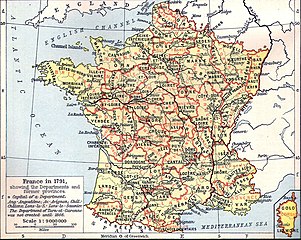
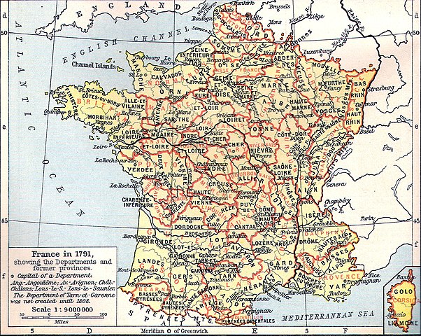
Français : Carte de la France en 1791 (départements et anciennes provinces - en rouge) in The Historical Atlas by William R. Shepherd, 1926
Lëtzebuergesch: Departementer vu Frankräich am Joer 1791. |
| Dátum | 2006. március 11. (eredeti feltöltésének dátuma) |
| Forrás | Áthozta Korrigan a fr.wikipedia projektből a Commonsba CommonsHelper használatával. |
| Szerző | Az eredeti feltöltő Tournachon a(z) francia Wikipédia projektből volt |
| Más változatok | Származékos művek: Départements et provinces de France.png |
Licenc
|
Ez a mű közkincs abban az országban, ahol elkészítették, és minden olyan további államban, ahol a szerzői jogi védelmi idő a szerző élete plusz 70 év vagy kevesebb.
| |
| Megállapították, hogy ez a fájl mentes mindenféle szerzői jogi korlátozástól, beleértve az összes kapcsolódó és hozzátartozó jogot. | |
Eredeti feltöltési napló
- 2006-03-11 14:51 Tournachon 741×599×??? (225908 bytes)
Fájltörténet
Kattints egy időpontra, hogy a fájl akkori állapotát láthasd.
| Dátum/idő | Bélyegkép | Felbontás | Feltöltő | Megjegyzés | |
|---|---|---|---|---|---|
| aktuális | 2022. július 22., 16:31 | | 1 635 × 1 303 (895 KB) | Hohum | Clearer version |
| 2012. január 25., 00:43 |  | 741 × 599 (634 KB) | MarcusBritish | Lower red tint. | |
| 2012. január 25., 00:41 |  | 741 × 599 (622 KB) | MarcusBritish | Improve tones/colour/contrast. | |
| 2008. szeptember 22., 10:46 |  | 741 × 599 (221 KB) | File Upload Bot (Magnus Manske) | {{BotMoveToCommons|fr.wikipedia}} {{Information |Description={{fr|Carte de la France en 1791 (départements et anciennes provinces - en rouge) in The Historical Atlas by William R. Shepherd, 1926 == Licence == [[:fr:Catégorie:Cartes Histoire de Fr |
Fájlhasználat
Az alábbi lapok használják ezt a fájlt:
Globális fájlhasználat
A következő wikik használják ezt a fájlt:
- Használata itt: als.wikipedia.org
- Használata itt: br.wikipedia.org
- Használata itt: de.wikipedia.org
- Használata itt: el.wikipedia.org
- Használata itt: eo.wikipedia.org
- Használata itt: es.wikipedia.org
- Használata itt: eu.wikipedia.org
- Használata itt: fi.wikipedia.org
- Használata itt: fr.wikipedia.org
- Használata itt: lb.wikipedia.org
- Használata itt: lv.wikipedia.org
- Használata itt: nn.wikipedia.org
- Használata itt: oc.wikipedia.org
- Használata itt: pl.wikipedia.org
.jpg)