
Fájl:Eyjafjallajökull volcanic ash 17 April 2010.png
Eyjafjallajökull_volcanic_ash_17_April_2010.png (680 × 520 képpont, fájlméret: 127 KB, MIME-típus: image/png)
|
Ez a fájl a Wikimedia Commonsból származik. Az alább látható leírás az ottani dokumentációjának másolata. A Commons projekt szabad licencű kép- és multimédiatár. Segíts te is az építésében! |

|
Ezt a képet el kellene készíteni vektorgrafika használatával SVG fájlként. A formátumnak számos előnye van; lásd a Commons:Media for cleanup lapot a további információkért. Ha a képnek már elérhető SVG-formátumú változata, töltsd fel. Az SVG feltöltése után cseréld le ezt a sablont a következőre: {{vector version available|új kép neve.svg}}.
|
| Leírás |
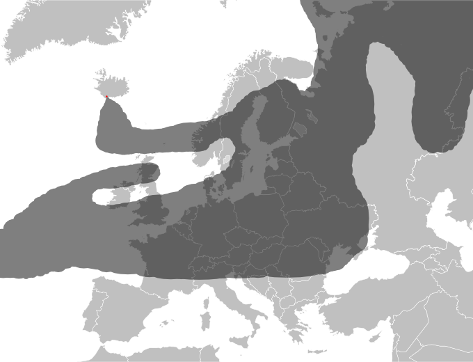
Approximate drawing of estimated ash cloud from the Eyjafjallajökull eruption as of 17 April 2010 at 18:00 UTC. Source: http://www.metoffice.gov.uk/aviation/vaac/data/VAG_1271527299.png Newer map: File:Eyjafjallajökull volcanic ash 19 April 2010.png Updates at http://www.metoffice.gov.uk/aviation/vaac/vaacuk_vag.html |
| Dátum | (UTC) |
| Forrás | |
| Szerző |
|
| Ez egy retusált kép, ami azt jelenti, hogy az eredetihez képest digitálisan módosították. Módosítások: drawed ash coverage. Az eredeti itt található: Blank map of Europe.svg. Módosította: Cogiati.
|
- A következőket teheted a művel:
- megoszthatod – szabadon másolhatod, terjesztheted, bemutathatod és előadhatod a művet
- feldolgozhatod – származékos műveket hozhatsz létre
- Az alábbi feltételekkel:
- Nevezd meg! – A szerzőt megfelelően fel kell tüntetned, hivatkozást kell létrehoznod a licencre és jelezned kell, ha a művön változtatást hajtottál végre. Ezt bármilyen észszerű módon megteheted, kivéve oly módon, ami azt sugallná hogy a jogosult támogat téged vagy a felhasználásod körülményeit.
- Így add tovább! – Ha megváltoztatod, átalakítod, feldolgozod ezt a művet, a közreműködésedet csak az eredetivel megegyező vagy hasonló licenc alatt terjesztheted.
Eredeti feltöltési napló
This image is a derivative work of the following images:
- File:Blank_map_of_Europe.svg licensed with Cc-by-sa-2.5
- 2008-09-17T09:50:25Z F7 680x520 (531491 Bytes)
- 2008-09-17T09:42:57Z F7 680x520 (2353 Bytes)
- 2008-05-26T19:04:07Z Collard 680x520 (531491 Bytes) uploading on behalf of [[User:Checkit]], direct complaints to him plox: 'Moved countries out of the "outlines" group, removed "outlines" style class, remove separate style information for Russia'
- 2008-04-30T01:38:52Z TimothyBourke 680x520 (531767 Bytes) Changed the country code of Serbia to RS per [http://en.wikipedia.org/wiki/Serbian_country_codes] and the file [http://www.iso.org/iso/iso3166_en_code_lists.txt].
- 2008-02-08T22:44:37Z CarolSpears 680x520 (531767 Bytes) validated
- 2007-07-10T11:47:59Z MrWeeble 680x520 (533112 Bytes) Updated to include British Crown Dependencies as seperate entities and regroup them as "British Islands", with some simplifications to the XML and CSS
- 2007-05-14T17:17:34Z Zirland 680x520 (540659 Bytes) serbia and montenegro
- 2007-03-30T20:40:49Z W!B: 680x520 (538830 Bytes) minor corr: update nl:Ijsselmeer, del fi:lakes (all small), add ru:lake Oneka (all ref maps.google), glued northern irland back to ie ;)
- 2007-02-05T18:44:32Z Maix 680x520 (538295 Bytes) cropped
- 2007-02-04T15:07:29Z Maix 680x520 (538310 Bytes) {{Information |Description=A blank Map of Europe in SVG format. Every country has an id which is its ISO-3116-1-ALPHA2 code in lower case for easy coloring. |Source=Image based on [[Image:Europe_countries.svg|]] by [[User:Ti
Uploaded with derivativeFX
Fájltörténet
Kattints egy időpontra, hogy a fájl akkori állapotát láthasd.
| Dátum/idő | Bélyegkép | Felbontás | Feltöltő | Megjegyzés | |
|---|---|---|---|---|---|
| aktuális | 2010. április 17., 23:24 | | 680 × 520 (127 KB) | Hydrox | Enhanced approximation of the same source. |
| 2010. április 17., 22:01 |  | 680 × 520 (127 KB) | Hydrox | Updated to reflect the data as of April 17th, 18:00 UTC (http://www.metoffice.gov.uk/aviation/vaac/data/VAG_1271527299.png) | |
| 2010. április 16., 18:43 |  | 680 × 520 (127 KB) | Cogiati | {{Information |Description=Approximate drawing of estimated ash cloud from the Eyjafjallajökull eruption as of 17 April 2010 at 06:00 UTC. Source: http://www.metoffice.gov.uk/aviation/vaac/data/VAG_1271417376.png Updates at http://www.metoffice.gov.uk/a |
Fájlhasználat
Az alábbi lapok használják ezt a fájlt:
Globális fájlhasználat
A következő wikik használják ezt a fájlt:
- Használata itt: an.wikipedia.org
- Használata itt: arz.wikipedia.org
- Használata itt: ca.wikipedia.org
- Használata itt: cs.wikipedia.org
- Használata itt: da.wikipedia.org
- Használata itt: de.wikipedia.org
- Használata itt: de.wikinews.org
- Használata itt: en.wikipedia.org
- Használata itt: en.wikinews.org
- Használata itt: eu.wikipedia.org
- Használata itt: fi.wikipedia.org
- Használata itt: fi.wikinews.org
- Használata itt: he.wikipedia.org
- Használata itt: hr.wikipedia.org
- Használata itt: hu.wikinews.org
- Használata itt: id.wikipedia.org
- Használata itt: incubator.wikimedia.org
- Használata itt: it.wikipedia.org
- Használata itt: ja.wikipedia.org
- Használata itt: jv.wikipedia.org
- Használata itt: km.wikipedia.org
- Használata itt: nl.wikipedia.org
- Használata itt: no.wikipedia.org
- Használata itt: pl.wikipedia.org
- Használata itt: pl.wikinews.org
- Használata itt: ru.wikipedia.org
- Használata itt: sh.wikipedia.org
- Használata itt: sr.wikipedia.org
- Használata itt: sv.wikipedia.org
- Használata itt: tr.wikinews.org
- Használata itt: uk.wikipedia.org