
Fájl:1867 U.S. Coast Survey Chart or Map of Puget Sound, Washington - Geographicus - PugetSound-uscs-1867.jpg
Eredeti fájl (4 000 × 6 404 képpont, fájlméret: 4,58 MB, MIME-típus: image/jpeg)
|
Ez a fájl a Wikimedia Commonsból származik. Az alább látható leírás az ottani dokumentációjának másolata. A Commons projekt szabad licencű kép- és multimédiatár. Segíts te is az építésében! |
| Puget Sound Washington Territory. | ||||||
|---|---|---|---|---|---|---|
| Művész | ||||||
| Mű címe |
Puget Sound Washington Territory. |
|||||
| Leírás |
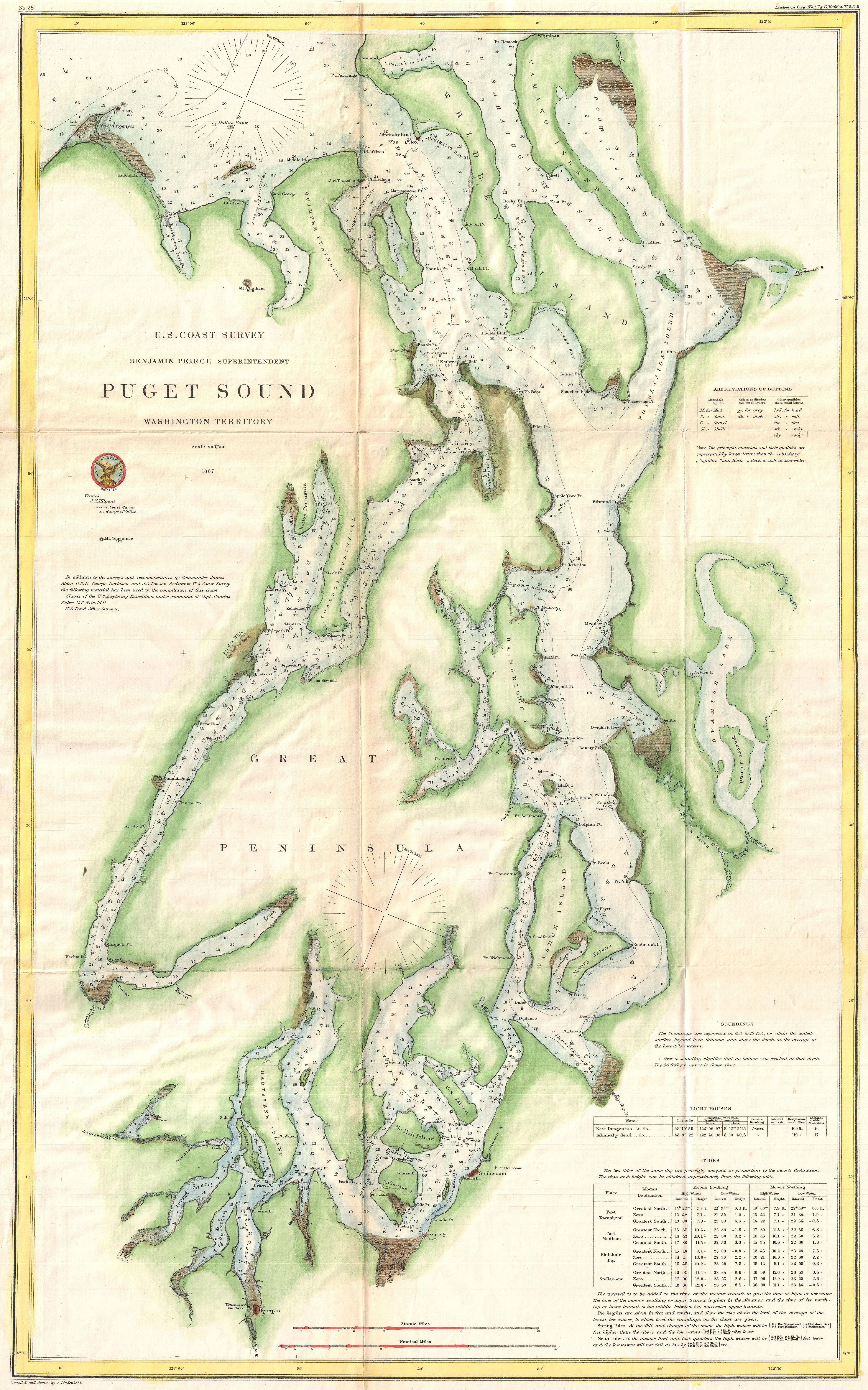
English: This is a very uncommon U.S. Coast Survey maritime map or nautical chart of the Puget Sound, Washington Territory, dating to 1867. Covers the Sound from Quimper Peninsula and Whidbey Island south as far as Olympia. The map identifies the various islands as well as safe channels and countless triangulation points throughout. Olympia, Nisqually, Steilacoom, and Seattle are named, though, aside from Olympia, most were undeveloped. Countless depth soundings appear throughout. Notes on soundings light houses, and tides appear in the lower right quadrant. Prepared under the supervision of Benjamin Pierce, Superintendent of the U.S. Coast Survey, for the 1867 Superintendent’s Report to Congress. |
|||||
| Dátum | 1867 (dated) | |||||
| Méretei | magasság: 28 hüvelyk (71,1 cm); szélesség: 17,5 hüvelyk (44,4 cm) | |||||
| Leltári szám |
Geographicus link: PugetSound-uscs-1867 |
|||||
| Forrás/fényképész |
Report of the Superintendent of the United States Coast Survey, (Washington) 1867.
|
|||||
| Engedély (Fájl újrafelhasználása) |
|
|||||
Fájltörténet
Kattints egy időpontra, hogy a fájl akkori állapotát láthasd.
| Dátum/idő | Bélyegkép | Felbontás | Feltöltő | Megjegyzés | |
|---|---|---|---|---|---|
| aktuális | 2011. március 25., 08:24 | | 4 000 × 6 404 (4,58 MB) | BotMultichillT | {{subst:User:Multichill/Geographicus |link=http://www.geographicus.com/P/AntiqueMap/PugetSound-uscs-1867 |product_name=1867 U.S. Coast Survey Chart or Map of Puget Sound, Washington |map_title=Puget Sound Washington Territory. |description=This is a very |
Fájlhasználat
Az alábbi lap használja ezt a fájlt:
Globális fájlhasználat
A következő wikik használják ezt a fájlt:
- Használata itt: en.wikipedia.org