
Fájl:Divided Yemen.svg

Ennek a(z) SVG fájlnak ezen PNG formátumú előnézete: 800 × 483 képpont. További felbontások: 320 × 193 képpont | 640 × 386 képpont | 1 024 × 618 képpont | 1 280 × 772 képpont | 2 560 × 1 544 képpont | 1 210 × 730 képpont.
Eredeti fájl (SVG fájl, névlegesen 1 210 × 730 képpont, fájlméret: 71 KB)
|
Ez a fájl a Wikimedia Commonsból származik. Az alább látható leírás az ottani dokumentációjának másolata. A Commons projekt szabad licencű kép- és multimédiatár. Segíts te is az építésében! |

|
Ez az SVG-fájl beágyazott szöveget tartalmaz, amit könnyen magyarra lehetne fordítani a bármilyen megfelelő SVG- vagy szövegszerkesztővel, vagy az SVG-fordító eszközzel. További információkért lásd: SVG-fájlok fordítása. |
Összefoglaló
| Leírás |
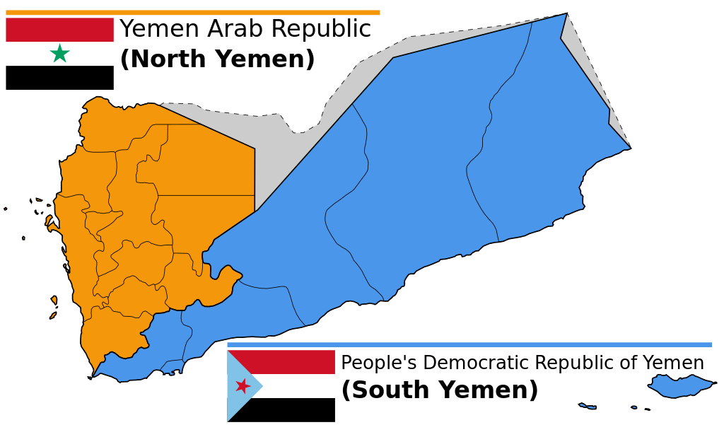
English: Map of North and South Yemen prior to unification.
Español: Yemen previo a la unificación, en 1990.
Français : Le Yémen avant l'unification.
Português: Iêmen do Norte (em laranja) e Iêmen do Sul (em azul) antes de 1990. |
| Dátum | (UTC) |
| Forrás | |
| Szerző |
|
| Más változatok |
|


.svg)


Licenc
Ez a fájl a Creative Commons Nevezd meg! – Így add tovább! 3.0 Unported licenc alapján használható fel.
- A következőket teheted a művel:
- megoszthatod – szabadon másolhatod, terjesztheted, bemutathatod és előadhatod a művet
- feldolgozhatod – származékos műveket hozhatsz létre
- Az alábbi feltételekkel:
- Nevezd meg! – A szerzőt megfelelően fel kell tüntetned, hivatkozást kell létrehoznod a licencre és jelezned kell, ha a művön változtatást hajtottál végre. Ezt bármilyen észszerű módon megteheted, kivéve oly módon, ami azt sugallná hogy a jogosult támogat téged vagy a felhasználásod körülményeit.
- Így add tovább! – Ha megváltoztatod, átalakítod, feldolgozod ezt a művet, a közreműködésedet csak az eredetivel megegyező vagy hasonló licenc alatt terjesztheted.
Eredeti feltöltési napló
This image is a derivative work of the following images:
- File:Map_of_North_and_South_Yemen.png licensed with Cc-by-sa-3.0, GFDL
- 2011-03-21T17:54:35Z Orange Tuesday 1600x1024 (63249 Bytes) 1600 px wide
- 2011-03-21T17:51:50Z Orange Tuesday 1598x1024 (63069 Bytes) {{Information |Description ={{en|1=Map of North and South Yemen prior to unification.}} |Source ={{own}} |Author =[[User:Orange Tuesday|Orange Tuesday]] |Date = |Permission = |other_versions =
- File:Flag_of_North_Yemen.svg licensed with PD-shape
- 2011-08-22T05:56:53Z Alkari 900x600 (731 Bytes) code cleanup; star precision; file size
- 2010-06-27T03:28:25Z Fry1989 900x600 (2295 Bytes) red
- 2006-01-17T05:29:39Z B1mbo 900x600 (665 Bytes) Few corrections
- 2006-01-17T05:15:33Z B1mbo 900x600 (1963 Bytes) == Sumario == {{en|Flag of the [[:en:Yemen Arab Republic|Yemen Arab Republic (North Yemen)]] (1962-1990)}} {{es|Bandera de la [[:es:Yemen del Norte|República Árabe de Yemen (Yemen del Norte)]] (1962-1990)}} [[Category:Flag
- File:Flag_of_South_Yemen.svg licensed with PD-self
- 2011-08-22T06:02:04Z Alkari 1800x1200 (804 Bytes) code cleanup; star precision
- 2010-06-27T03:26:35Z Fry1989 1800x1200 (2702 Bytes) shades
- 2006-01-08T18:55:08Z Dbenbenn 1800x1200 (946 Bytes) by me, PD. Based on https://www.fotw.info/flags/ye-south.html
- 2006-01-04T23:52:54Z Chanheigeorge 195x130 (3741 Bytes) Converted from Image:South_Yemen_Flag.PNG
- File:Governorates_of_Yemen_named.svg licensed with Cc-by-sa-2.5,2.0,1.0, Cc-by-sa-3.0-migrated, GFDL
- 2007-05-23T17:35:54Z Jarke 1208x719 (77247 Bytes) == Sumario == {{Information |Description={{en|Governorates of Yemen, after 2004}} {{es|Governaciones de Yemen, después del 2004}} |Source=SVG version of [[:Image:Yemen governorates numbered english.png]] and [[:Imagen:Yemen
Uploaded with derivativeFX
Fájltörténet
Kattints egy időpontra, hogy a fájl akkori állapotát láthasd.
| Dátum/idő | Bélyegkép | Felbontás | Feltöltő | Megjegyzés | |
|---|---|---|---|---|---|
| aktuális | 2023. december 20., 16:58 | | 1 210 × 730 (71 KB) | אורי9 | File uploaded using svgtranslate tool (https://svgtranslate.toolforge.org/). Added translation for he. |
| 2020. november 8., 21:47 |  | 1 210 × 730 (71 KB) | Panam2014 | Reverted to version as of 18:27, 8 July 2019 (UTC) | |
| 2020. augusztus 9., 10:46 |  | 1 210 × 730 (44 KB) | AlMahra67 | text | |
| 2020. augusztus 3., 20:05 |  | 1 210 × 730 (39 KB) | AlMahra67 | Changed dimensions | |
| 2020. augusztus 3., 19:50 |  | 512 × 309 (39 KB) | AlMahra67 | If this map is supposed to show South and North Yemen division currently then it should be like this. The current divisions are based on the former divisions between the North and South Yemen. The previous version showed the new administrative boundaries that were created after unity. The new administrative boundary split areas that were part of the south. For example Dhale and Mukayras are shown as part of the North when they are in fact Southern. | |
| 2019. augusztus 12., 01:07 |  | 1 210 × 730 (47 KB) | SharabSalam | Reverted to version as of 19:35, 20 October 2012 (UTC) none of these sources support this map. This map suppose to show South and North Yemen division currently.. Also Asir, Jazan and Najran should be part of North Yemen if it's a historical map. | |
| 2019. július 8., 20:27 |  | 1 210 × 730 (71 KB) | Flappiefh | This map is supposed to show these two former countries before their union (before 1990). It now shows the right governorates. Source 1 : https://legacy.lib.utexas.edu/maps/atlas_middle_east/yemen_divisions.jpg Source 2 : http://users.ox.ac.uk/~metheses/Ismail%20Thesis.pdf | |
| 2018. szeptember 23., 13:57 |  | 1 210 × 730 (68 KB) | Nicolay Sidorov | ... | |
| 2018. szeptember 23., 13:52 |  | 1 210 × 730 (65 KB) | Nicolay Sidorov | true border | |
| 2016. június 11., 10:59 |  | 1 210 × 730 (47 KB) | Flappiefh | Removed Dhale Governorate because it didn't exist at that time (created after 1990 unification). |
Fájlhasználat
Az alábbi lap használja ezt a fájlt:
Globális fájlhasználat
A következő wikik használják ezt a fájlt:
- Használata itt: af.wikipedia.org
- Használata itt: bn.wikipedia.org
- Használata itt: ca.wikipedia.org
- Használata itt: cs.wikipedia.org
- Használata itt: en.wikipedia.org
- Használata itt: es.wikipedia.org
- Használata itt: eu.wikipedia.org
- Használata itt: fa.wikipedia.org
- Használata itt: fi.wikipedia.org
- Használata itt: fr.wikipedia.org
- Használata itt: gl.wikipedia.org
- Használata itt: he.wikipedia.org
- פורטל:גאוגרפיה/הידעת?/קטעי הידעת
- פורטל:המזרח התיכון/הידעת?/קטעי הידעת?
- ויקיפדיה:הידעת?/ממרץ 2016
- איחוד תימן
- ויקיפדיה:הידעת?/2017/ינואר
- תבנית:הידעת? 071
- תבנית:הידעת? 30 בינואר 2017
- ויקיפדיה:הידעת?/2021/אוקטובר
- תבנית:הידעת? 20 באוקטובר 2021
- פורטל:גאוגרפיה/הידעת?/34
- פורטל:המזרח התיכון/הידעת?/63
- התנועה הדרומית
- Használata itt: hr.wikipedia.org
- Használata itt: hy.wikipedia.org
- Használata itt: id.wikipedia.org
- Használata itt: it.wikipedia.org
- Használata itt: ja.wikipedia.org
- Használata itt: ka.wikipedia.org
- Használata itt: ms.wikipedia.org
- Használata itt: nl.wikipedia.org
- Használata itt: nn.wikipedia.org
- Használata itt: or.wikipedia.org
- Használata itt: sr.wikipedia.org
- Használata itt: te.wikipedia.org
- Használata itt: tg.wikipedia.org
- Használata itt: tr.wikipedia.org
A fájl globális használatának megtekintése