
Fájl:Ctcolony.png

Az előnézet mérete: 800 × 560 képpont További felbontások: 320 × 224 képpont | 640 × 448 képpont | 1 024 × 717 képpont | 1 428 × 1 000 képpont.
Eredeti fájl (1 428 × 1 000 képpont, fájlméret: 817 KB, MIME-típus: image/png)
|
Ez a fájl a Wikimedia Commonsból származik. Az alább látható leírás az ottani dokumentációjának másolata. A Commons projekt szabad licencű kép- és multimédiatár. Segíts te is az építésében! |
Összefoglaló
| Leírás |
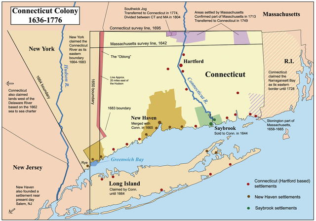
This is a map showing the Connecticut, New Haven, and Saybrook colonies from 1636-1776. It includes the territorial disputes between Connecticut and its neighbors during that time period. It does not show Connecticut's western land claims and dispute with Pennsylvania. Based primarily on descriptions from The Boundary Disputes of Connecticut by Clarence Winthrop Bowen. James R. Osgood and Company, Boston, 1882. |
| Dátum | 2006. október 12. (eredeti feltöltésének dátuma) |
| Forrás | Nincs megadva géppel olvasható forrás. Feltételezhetően saját munka (a szerzői jogi adatok alapján). |
| Szerző | Nincs megadva géppel olvasható szerző. Feltételezhetően Kmusser (a szerzői jogi adatok alapján). |
Licenc
Én, e mű szerzője a művemet az alábbi licenc alatt teszem közzé:
Ez a fájl a Creative Commons Nevezd meg! – Így add tovább! 2.5 Általános licenc alapján használható fel.
- A következőket teheted a művel:
- megoszthatod – szabadon másolhatod, terjesztheted, bemutathatod és előadhatod a művet
- feldolgozhatod – származékos műveket hozhatsz létre
- Az alábbi feltételekkel:
- Nevezd meg! – A szerzőt megfelelően fel kell tüntetned, hivatkozást kell létrehoznod a licencre és jelezned kell, ha a művön változtatást hajtottál végre. Ezt bármilyen észszerű módon megteheted, kivéve oly módon, ami azt sugallná hogy a jogosult támogat téged vagy a felhasználásod körülményeit.
- Így add tovább! – Ha megváltoztatod, átalakítod, feldolgozod ezt a művet, a közreműködésedet csak az eredetivel megegyező vagy hasonló licenc alatt terjesztheted.
Format

|
Ezt a képet el kellene készíteni vektorgrafika használatával SVG fájlként. A formátumnak számos előnye van; lásd a Commons:Media for cleanup lapot a további információkért. Ha a képnek már elérhető SVG-formátumú változata, töltsd fel. Az SVG feltöltése után cseréld le ezt a sablont a következőre: {{vector version available|új kép neve.svg}}.
|
Fájltörténet
Kattints egy időpontra, hogy a fájl akkori állapotát láthasd.
| Dátum/idő | Bélyegkép | Felbontás | Feltöltő | Megjegyzés | |
|---|---|---|---|---|---|
| aktuális | 2014. június 2., 06:06 | | 1 428 × 1 000 (817 KB) | JeffyP | I'm here to make the world a little bit smaller ☺ |
| 2008. január 10., 21:19 |  | 1 428 × 1 000 (909 KB) | Kmusser | Major revision to include disputes with Massachusetts and Rhode Island. | |
| 2006. október 12., 18:54 |  | 800 × 680 (190 KB) | Kmusser | == Summary == This is a map showing the Connecticut, New Haven, and Saybrook colonies from 1636-1776. It includes the territorial dispute between Connecticut |
Fájlhasználat
Az alábbi lap használja ezt a fájlt:
Globális fájlhasználat
A következő wikik használják ezt a fájlt:
- Használata itt: bg.wikipedia.org
- Használata itt: bn.wikipedia.org
- Használata itt: ce.wikipedia.org
- Használata itt: da.wikipedia.org
- Használata itt: de.wikipedia.org
- Használata itt: en.wikipedia.org
- Connecticut
- Fishers Island, New York
- New Haven Colony
- History of Connecticut
- Connecticut Colony
- John Haynes (governor)
- Saybrook Colony
- User:Kmusser/Images
- List of colonial governors of Connecticut
- History of Long Island
- New England Colonies
- Portal:Connecticut
- Thomas Powell (American landowner)
- Border disputes between New York and Connecticut
- User:Falcaorib/Canada, United States and Mexico
- Használata itt: en.wikiversity.org
- Használata itt: es.wikipedia.org
- Használata itt: fr.wikipedia.org
- Használata itt: fy.wikipedia.org
- Használata itt: he.wikipedia.org
- Használata itt: hy.wikipedia.org
- Használata itt: id.wikipedia.org
- Használata itt: it.wikipedia.org
- Használata itt: ja.wikipedia.org
A fájl globális használatának megtekintése