
Fájl:Congo regions named.png
Nem érhető el nagyobb felbontású változat.
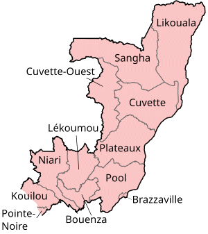
Congo_regions_named.png (300 × 337 képpont, fájlméret: 14 KB, MIME-típus: image/png)
|
Ez a fájl a Wikimedia Commonsból származik. Az alább látható leírás az ottani dokumentációjának másolata. A Commons projekt szabad licencű kép- és multimédiatár. Segíts te is az építésében! |
| Leírás |
Map of the regions of the Republic of the Congo, named in French (local language), mostly compatible with English. The individual maps are: |
| Dátum | |
| Forrás | Self-made, traced from public domain UN or CIA maps. |
| Szerző | User:Golbez |
| Engedély (Fájl újrafelhasználása) |
Provide attribution, please. See below. |
Én, e mű szerzője a művemet az alábbi licencek alatt teszem közzé:
Ez a fájl a Creative Commons Nevezd meg! – Így add tovább! 2.5 Általános, 2.0 Általános és 1.0 Általános licencek alapján használható fel.
- A következőket teheted a művel:
- megoszthatod – szabadon másolhatod, terjesztheted, bemutathatod és előadhatod a művet
- feldolgozhatod – származékos műveket hozhatsz létre
- Az alábbi feltételekkel:
- Nevezd meg! – A szerzőt megfelelően fel kell tüntetned, hivatkozást kell létrehoznod a licencre és jelezned kell, ha a művön változtatást hajtottál végre. Ezt bármilyen észszerű módon megteheted, kivéve oly módon, ami azt sugallná hogy a jogosult támogat téged vagy a felhasználásod körülményeit.
- Így add tovább! – Ha megváltoztatod, átalakítod, feldolgozod ezt a művet, a közreműködésedet csak az eredetivel megegyező vagy hasonló licenc alatt terjesztheted.

|
Ez a fájl szabadon másolható, terjeszthető és/vagy módosítható a GNU Szabad Dokumentációs Licenc feltételei alapján, az 1.2 vagy későbbi, a Free Software Foundation által publikált Nem Változtatható szakaszok, Címlapszövegek és Hátlapszövegek nélküli változat szerint. E licenc egy példánya a GNU Szabad Dokumentációs Licenc című fejezetben olvasható. |
| Ez a fájl a Creative Commons Nevezd meg! – Így add tovább! 3.0 Unported licenc alapján használható fel. | ||
| ||
| Ez a licenc a GFDL licenccsere során került a fájlra. |
A mű a fenti licencek bármelyike szerint felhasználható.
Fájltörténet
Kattints egy időpontra, hogy a fájl akkori állapotát láthasd.
| Dátum/idő | Bélyegkép | Felbontás | Feltöltő | Megjegyzés | |
|---|---|---|---|---|---|
| aktuális | 2023. október 1., 19:29 | | 300 × 337 (14 KB) | Yunan973 | fix all boundaries according to last offical maps (2023) |
| 2004. december 28., 18:53 |  | 300 × 370 (13 KB) | Golbez | Map of the regions of the Republic of the Congo. Made by User:Golbez. {{cc-by-sa-2.0}} |
Fájlhasználat
Az alábbi lap használja ezt a fájlt:
Globális fájlhasználat
A következő wikik használják ezt a fájlt:
- Használata itt: ast.wikipedia.org
- Használata itt: avk.wikipedia.org
- Használata itt: be-tarask.wikipedia.org
- Használata itt: bg.wikipedia.org
- Használata itt: bn.wikipedia.org
- Használata itt: br.wikipedia.org
- Használata itt: ca.wikipedia.org
- Használata itt: de.wikipedia.org
- Használata itt: el.wikipedia.org
- Használata itt: en.wikipedia.org
- Departments of the Republic of the Congo
- Pointe-Noire
- Districts of the Republic of the Congo
- User:Jonny-mt/Gallery of current first-level administrative country subdivisions maps
- Kimongo District
- Mayoko District
- Divénié District
- Louvakou District
- Template:Districts of the Republic of the Congo
- User talk:Markussep/Archive 4
- Kibangou District
- Moutamba District
- Boko-Songho District
- Loudima District
- Madingou District
- Mfouati District
- Mouyondzi District
- Kayes District
- Boundji District
- Loukela District
- Makoua District
- Mossaka District
- Okoyo District
- Oyo District
- Ewo District
- Kelle District
- Mbomo District
- Kakamoeka District
- Madingo-Kayes District
- Mvouti District
- Bambama District
- Komono District
- Sibiti District
- Zanaga District
- Dongou District
- Epena District
- Impfondo District
A fájl globális használatának megtekintése