
Fájl:British Islands.svg

Ennek a(z) SVG fájlnak ezen PNG formátumú előnézete: 343 × 600 képpont. További felbontások: 137 × 240 képpont | 274 × 480 képpont | 439 × 768 képpont | 586 × 1 024 képpont | 1 171 × 2 048 képpont | 675 × 1 180 képpont.
Eredeti fájl (SVG fájl, névlegesen 675 × 1 180 képpont, fájlméret: 243 KB)
|
Ez a fájl a Wikimedia Commonsból származik. Az alább látható leírás az ottani dokumentációjának másolata. A Commons projekt szabad licencű kép- és multimédiatár. Segíts te is az építésében! |
Összefoglaló
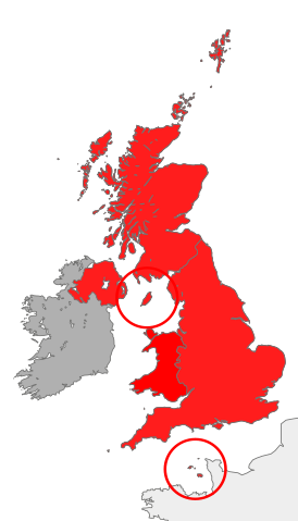
| Leírás | map showing the territory referred to as "the British Islands" in relation to Great Britain and Ireland (namely the United Kingdom plus the Crown Dependencies, but not the Republic of Ireland) |
| Dátum | |
| Forrás | A feltöltő saját munkája |
| Szerző | Cnbrb |
| SVG kód | Ez vektorgrafikus kép Inkscape segítségével készült. |
Licenc
| Én, a szerző, ezt a művemet ezennel közkinccsé nyilvánítom. Ez a világ minden részén érvényes. Egyes országokban ez jogilag nem lehetséges. Ha így van, akkor: Jogot adok bárkinek, hogy bármilyen célból, feltétel nélkül használhassa ezt a fájlt, kivéve a törvény által kötelezően előírt feltételeket. |
Fájltörténet
Kattints egy időpontra, hogy a fájl akkori állapotát láthasd.
| Dátum/idő | Bélyegkép | Felbontás | Feltöltő | Megjegyzés | |
|---|---|---|---|---|---|
| aktuális | 2016. október 28., 14:45 | | 675 × 1 180 (243 KB) | Smyth | Highlight crown dependencies, otherwise map looks identical to File:British Isles United Kingdom.svg at small sizes. |
| 2007. október 20., 23:32 |  | 675 × 1 180 (241 KB) | Cnbrb | == Summary == {{Information |Description=map showing the territory referred to as "the British Islands" in relation to Great Britain and Ireland (namely the United Kingdom plus the Crown Dependencies, but not the Republic of Ireland) |Source=self-made |Da |
Fájlhasználat
Az alábbi lapok használják ezt a fájlt:
Globális fájlhasználat
A következő wikik használják ezt a fájlt:
- Használata itt: cs.wikipedia.org
- Használata itt: en.wikipedia.org
- Használata itt: es.wikipedia.org
- Használata itt: fa.wikipedia.org
- Használata itt: fr.wiktionary.org
- Használata itt: he.wikipedia.org
- Használata itt: id.wikipedia.org
- Használata itt: it.wikipedia.org
- Használata itt: kk.wikipedia.org
- Használata itt: lt.wikipedia.org
- Használata itt: ru.wikipedia.org
- Használata itt: si.wikipedia.org
- Használata itt: sr.wikipedia.org
- Használata itt: sv.wikipedia.org
- Használata itt: tr.wikipedia.org
- Használata itt: uk.wikipedia.org
- Használata itt: vi.wikipedia.org
- Használata itt: zh.wikipedia.org