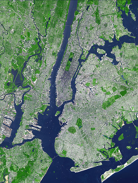
Fájl:Aster newyorkcity lrg.jpg
Megjelenés

Az előnézet mérete: 452 × 600 képpont További felbontások: 181 × 240 képpont | 361 × 480 képpont | 578 × 768 képpont | 771 × 1 024 képpont | 1 964 × 2 607 képpont.
Eredeti fájl (1 964 × 2 607 képpont, fájlméret: 3,31 MB, MIME-típus: image/jpeg)
Fájltörténet
Kattints egy időpontra, hogy a fájl akkori állapotát láthasd.
| Dátum/idő | Bélyegkép | Felbontás | Feltöltő | Megjegyzés | |
|---|---|---|---|---|---|
| aktuális | 2007. augusztus 8., 19:54 |  | 1 964 × 2 607 (3,31 MB) | HenrikRomby | {{Information |Description=This false-color satellite image shows Greater New York City. The Island of Manhattan juts southward from top center, bordered by the Hudson River to the west and the East River to the east (north is straight up in this scene.) |
Fájlhasználat
Az alábbi lap használja ezt a fájlt:
Globális fájlhasználat
A következő wikik használják ezt a fájlt:
- Használata itt: af.wikipedia.org
- Használata itt: ar.wikipedia.org
- Használata itt: ast.wikipedia.org
- Használata itt: bn.wikipedia.org
- Használata itt: ca.wikipedia.org
- Használata itt: da.wikipedia.org
- Használata itt: de.wikipedia.org
- Használata itt: el.wikipedia.org
- Használata itt: en.wikipedia.org
- Topography
- Hudson County, New Jersey
- User:TimAlderson/Userboxes
- Hudson Waterfront
- List of bridges, tunnels, and cuts in Hudson County, New Jersey
- User:NYCRuss/Sandbox/New York City
- Trees of New York City
- Talk:Trees of New York City
- Wikipedia:WikiProject New York City/Environment Task Force
- Wikipedia:WikiProject New York City/400 Task Force
- Használata itt: en.wikibooks.org
- Használata itt: eo.wikipedia.org
- Használata itt: es.wikipedia.org
- Használata itt: et.wikipedia.org
- Használata itt: fi.wikipedia.org
- Használata itt: fr.wikipedia.org
- Használata itt: fr.wikinews.org
- Használata itt: gl.wikipedia.org
- Használata itt: he.wikipedia.org
- Használata itt: hr.wikipedia.org
- Használata itt: hy.wikipedia.org
- Használata itt: id.wikipedia.org
- Használata itt: it.wikipedia.org
- Használata itt: ja.wikipedia.org
A fájl globális használatának megtekintése


